


Oak 2 Voting District, Smith County, Kansas
About
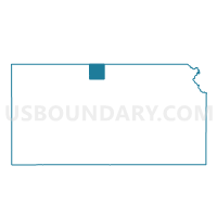
Outline

Summary
| Unique Area Identifier | 587422 |
| Name | Oak 2 Voting District |
| County | Smith County |
| State | Kansas |
| Area (square miles) | 18.19 |
| Land Area (square miles) | 18.19 |
| Water Area (square miles) | 0.00 |
| % of Land Area | 100.00 |
| % of Water Area | 0.00 |
| Latitude of the Internal Point | 39.78499740 |
| Longtitude of the Internal Point | -98.58809610 |
Maps


Graphs
Select a template below for downloading or customizing gragh for Oak 2 Voting District, Smith County, Kansas


Neighbors
Neighoring Voting District (by Name) Neighboring Voting District on the Map
- Blaine Township Voting District, Smith County, KS
- Cora Township Voting District, Smith County, KS
- Crystal Plains Township Voting District, Smith County, KS
- Oak 1 Voting District, Smith County, KS
- Webster Township Voting District, Smith County, KS
- White Rock Township Voting District, Smith County, KS
Top 10 Neighboring County Subdivision (by Population) Neighboring County Subdivision on the Map
- Oak township, Smith County, KS (285)
- Blaine township, Smith County, KS (48)
- Webster township, Smith County, KS (43)
- White Rock township, Smith County, KS (43)
- Crystal Plains township, Smith County, KS (27)
- Cora township, Smith County, KS (26)